


Our Good Question! series fields a lot of questions around Pittsburgh transit, from the history of streetcars to the creation of light rail. We pulled together a variety of questions for this short history.
In 1859, Pittsburgh was the 17th largest city in the United States, housed nearly 1,000 factories and was a major industrial force. The town of about 50,000 was in the middle of earning its nickname, the Steel City, producing large amounts of the strong material and growing each year.
The city’s growth had a natural limit, though. Throughout most of the 19th century, according to Port Authority service manager and historian Chris Walker, people usually lived close to where they worked because they had to walk. It wasn’t rare for someone to live their entire life within a few dozen miles of where they were born.
“The size of a city was limited to how far you could walk to work,” Walker said.
But that year, 1859, the city’s first public transit system began operations: a horse-drawn carriage carrying passengers from downtown Pittsburgh to 34th Street and Penn Avenue. It was a big deal.

“It would allow people to live in one neighborhood and work somewhere else,” Walker said. “That’s the big takeaway we have in public transit--it’s really changed people’s lives from the beginning.”
As the city grew and technology evolved, so did transportation systems in Pittsburgh.
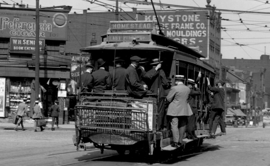
Walker said three cable cars--which are motor-powered vehicles connected to a continuously moving cable--ran from downtown to East Liberty. The 91, 88 and 71B only lasted about a decade before they were replaced in favor of electric street cars, or trolleys, because they were more effective. Approaching the turn of the century, trolley lines weaved throughout the region, connecting the city as it was rapidly annexing boroughs and townships.

“Once the trolley technology had been perfected to the point where it was applicable on a large scale, it just took off like a rocket in popularity,” Walker said. “[Trolley companies] were the tech startups of the 1890s, everybody had to get in on it.”
Suburbanization becomes trendy
Trolley ridership peaked in 1920, when the city’s population was 588,343--nearly double the population it is today. But even then, Walker said, suburbanization and automobile-centric lifestyles were starting to affect transit trends. That shift was slowed during the Great Depression and WWII, according to Port Authority Assistant Manager of Road Operations and historian Chuck Rompala.
“There was gas rationing in WWII, everybody was concerned about what was happening overseas,” Rompala said. “Everyone rode transit.”
When the war ended and soldiers returned home, many families moved to the city’s growing suburbs and bought their own car. People began spending more time at home or driving to their destinations.

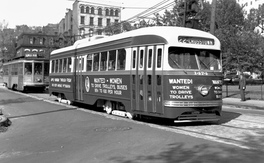
Those changes exacerbated another problem: by the early 1950s, there were 33 different privately-owned transportation companies that ran bus, incline and trolley routes around the region. The Pittsburgh Railways Company was the largest, operating 666 streetcars. (A preserved PCC vehicle is in the lobby of the Heinz History Center.)
There were also a few railroads in the area that were running passenger trains, including the Baltimore and Ohio Railroad and Pittsburgh and Lake Erie Railroad.
These 33 different companies had different fare systems and separate drivers’ unions that paid different wages. Many ran their vehicles on overlapping routes. And with declining ridership, each company was struggling to make money.
“Oftentimes there were competitions between some of the bus companies who literally would place buses in front of streetcars and take their passengers,” Rompala said. “There was competitiveness at the street level.”
Port Authority is born
Citing the region’s inadequate transit system, the Pennsylvania General Assembly legislated the Port Authority of Allegheny County into existence in 1956. This group, with a small board and few staffers, would be in charge of consolidating the 33 different companies.
Rompala said the merger was no easy task.
“It was literally a spider web of policies, procedures, wages, contractual obligations,” Rompala said.
In 1964, PAT’s board asked consultants to look at the best way to consolidate transit in the Pittsburgh area. These experts created the Early Action Program, which laid out proposals like the construction of a rapid transit system.

But the document also determined that operating, maintaining and repairing the city’s streetcars would be very expensive. Port Authority assistant service manager and historian Fred Mergner said sure, streetcars were bigger and could carry more people, but buses were much, much cheaper, and didn’t need major repairs.
“That’s a thing people ask about a lot: why doesn’t [the streetcar network] exist anymore?” Mergner said. “The analysis was done and they said [most streetcars] would probably last until about 1972 and then it would start falling into some serious disrepair.”

Without significant capital investment, PAT decided to slowly scrap the streetcars in favor of rubber-wheeled vehicles, like buses.
“It was done for economic reasons,” Mergner said. “It was a way to save the taxpayer from having to replace all that streetcar infrastructure.”
Trolleys weren’t immediately phased out, but Port Authority began focusing more on their buses, changing some routes, adding park and rides for suburban dwellers and rolling out the new colorful and striped “mod” style vehicles.
Some federal funding came in to help the young PAT purchase a few hundred new buses. Route names were adjusted to reflect the new alpha-numeric system, which was based on city corridors. If a bus route ended in a 1 or a 6, that indicated it would go through downtown. As routes branched out into neighborhoods, a letter, A-D, would be added. There were also express routes during rush hour and premium routes that ran on faster roads like Boulevard of the Allies and Bigelow Boulevard.
Numbering was on a compass point design, according to Rompala.
“You basically started in the Allegheny Valley and went in a counterclockwise move until you got to 91,” he said.
On July 6, 1985, streetcars rolled through downtown for the final time. Mergner said he remembers hopping on the last trip around midnight.
“They had fireworks on the track on Smithfield Street and we went over across the bridge and back to Station Square and everybody got out for a picture,” Mergner said.
Light rail and the East Busway
Around the same time the trolley disappeared, work began on the light rail T system.
“Light rail terminology came about because [no one] wanted to call them street cars anymore, it was old fashioned,” Rompala said.
PAT officials had decided that the rail lines to the South Hills should be maintained because they were built on lengthy, private roads, away from busy streets.
“They realized that would have some kind of value, having all those exclusive rights of way running parallel to some very congested highway corridors,” Mergner said.

That’s why there’s no Parkway South, Walker said--the rail line was always meant to be the connector to those neighborhoods.
While workers constructed the T lines, there was controversy about whether the downtown subway portion should be built under Fifth Avenue or Sixth Avenue. Mergner said the Sixth Avenue corridor was eventually chosen based on its alignment to the Pennsylvania Railroad Station. Plus, the One Mellon Center skyscraper was slated to be built and the area had already been prepared for construction.
Meanwhile, in 1983, the Martin Luther King Jr. East Busway opened, providing the city’s eastern neighborhoods a fast track to downtown Pittsburgh. The success of the South Busway, which ran on an exclusive right of way to avoid the congested Route 51, motivated officials to built a similar type of route to the east.
“In my opinion, to this day, it was the best thing that was ever built in Pittsburgh infrastructure-wise,” Mergner said. “The bus trip from downtown to East Liberty at rush hour was, at minimum, 45 minutes, and to Wilkinsburg, an hour. It was a long, long ride.”
PAT marketed the new route as “East Busway, the best way.” Part of the movie Flashdance was filmed at the construction site at the stop near Penn Station. Mergner said close to 30,000 people use the route each day, including express route services like the Holiday Park Flyer and Monroeville Flyer.
This is part of our Good Question! series where we investigate what you've always wondered about Pittsburgh, its people and its culture.
“There’s no way you can beat the time savings from using that versus sitting on the Parkway,” he said.Busway opened, providing the city’s eastern neighborhoods a fast track to downtown Pittsburgh. The success of the South Busway, which ran on an exclusive right of way to avoid the congested Route 51, motivated officials to built a similar type of route to the east.
“In my opinion, to this day, it was the best thing that was ever built in Pittsburgh infrastructure-wise,” Mergner said. “The bus trip from downtown to East Liberty at rush hour was, at minimum, 45 minutes, and to Wilkinsburg, an hour. It was a long, long ride.”
The T rides North
Nearly 20 years after the South Hills T was built, work began on the North Shore connector that would link the Gateway Center T station to Heinz Field, at the North Shore station. Rompala said this wasn’t very popular at the time, largely due to the $500 million price tag, but development along the rivers was bringing more and more people to the area.
“They were building a new David L. Lawrence Convention Center, they were building PNC Park and Heinz Field,” he said. “They wanted to have this new transportation system.”

Crew bored a tunnel from the Golden Triangle through the bedrock of the Allegheny River, finishing the 1.5 mile probject in 2008. Rompala said it’s been hugely popular since, especially when there are big events on the North Shore.
“Within 15 minutes we move something like 7,000-12,000 people from a Steelers game,” Rompala said. He estimates that about 12 percent of the stadium capacity uses the North Shore connector during games.
Transit enthusiasts come from around the world to visit Pittsburgh, Rompala said, to see the evolution from heavy rail commuter trains to the modern light rail T system. And, the PAT historians added, new systems, like Bus Rapid Transit, are still being planned for the region.


